LANDSCAPE ANALYSIS: region of N'KOSY (Uganda)
Step 1. Google Earth
Foreword: Learn the basics of Google Earth® software
Google Earth® is extremely useful to obtain information on any area in the world, in particular where there are no maps or other resources available that describe the environment. (Download GoogleEarth here)
- -------------------------------------
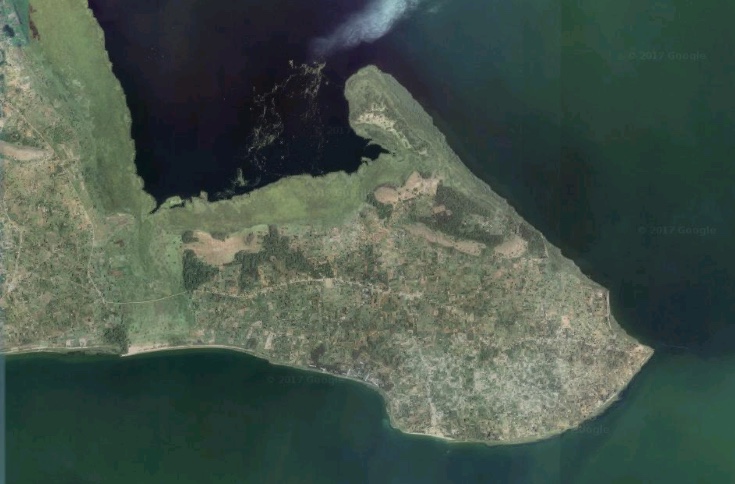
 Here we are un Uganda, in the region of N'Kosy, with Didier Pillot. As we have no topographical map of this area, we are going to carry out our initial analysis using satellite images.
- General description of the studied area and the method
- First observations on satellite data
 Exercise for yourself: Analysis of the peninsula. Using the satellite images, identify the different environments and proceed with an initial zoning of the peninsula.Then trace a route that will allow you to observe the field in the different types of environment.
To view the study zone for the exercise on Google Maps, click on this image.
- Detailed observation of each part of the peninsula
- Establish a transect
Explore the N'Kosy area with the picture tour.
Advice: this visit uses the software Prezi®. If you are not familiar with this software, we recommend that, to begin with, you only use the arrows <= and => on your keyboard to browse through this presentation.
 From an elevated point, Didier Pillot and his group of students compare their observations with those already made with Google Earth®.
- Find our way in the field
- Observe cultivated land
- Observe land occupation
- Observe the soils
- What kind of tools do we need to observe the landscape
- Second high point: the peninsula
- Groups split up to cover the study area
Step 2. From field observation to zoning
 The agrarian landscape is extremely rich and varied. Didier Pillot gives you some advice on the discriminating elements to be observed.
- The key features of the landscape depend on the context
- Frequent important elements of the landscape
 Didier Pillot presents the advantages and disadvantages of carrying out field observations alone or in a group.
- Everyone looks at the landscape in his own way
- Individual or group observation
 Didier Pillot presents the observation instructions given to the group.
- Broad context: several groups studied the landscape
- The groups looked for specific elements in the landscape
- The groups' results

Didier Pillot presents the results for the student group 5: A representation of their transect, identifying the homogeneous agro-ecological zones.
Group 5’s results (9'30) File 124.8MB
- Group 5 path
- Description of the 3 types of zones found
- Student results
Step 3. Synthesis of zoning
Each group of students carried out landscape observations on their transect and created their own zoning. We must now, in several steps, summarise their different results to obtain a coherent global zoning for the study area.
 Exercise: Aggregate the groups’ results to obtain a single synthetic zoning.
Step 4. An iterative process to achieve a validated zoning
 Didier Pillot describes the final zoning obtained by aggregating the work produced by all of the groups.
 A choice must be made between an exhaustive description or one that is too general. Didier Pillot looks the number of zones to be composed and their level of precision.
 It is not easy to establish the boundaries between the different zones. Didier Pillot goes back into the field to make the final decision.
- Compare the results with the field
- Example: adjusting zone boundaries